Focus of this guide
Great Salt Flat Argentina means Salinas Grandes, Jujuy.
From Purmamarca, RN 52 climbs through Cuesta de Lipán before reaching the salt flat. The road journey is part of the experience and requires high-altitude preparation.
 SalinasGrandesES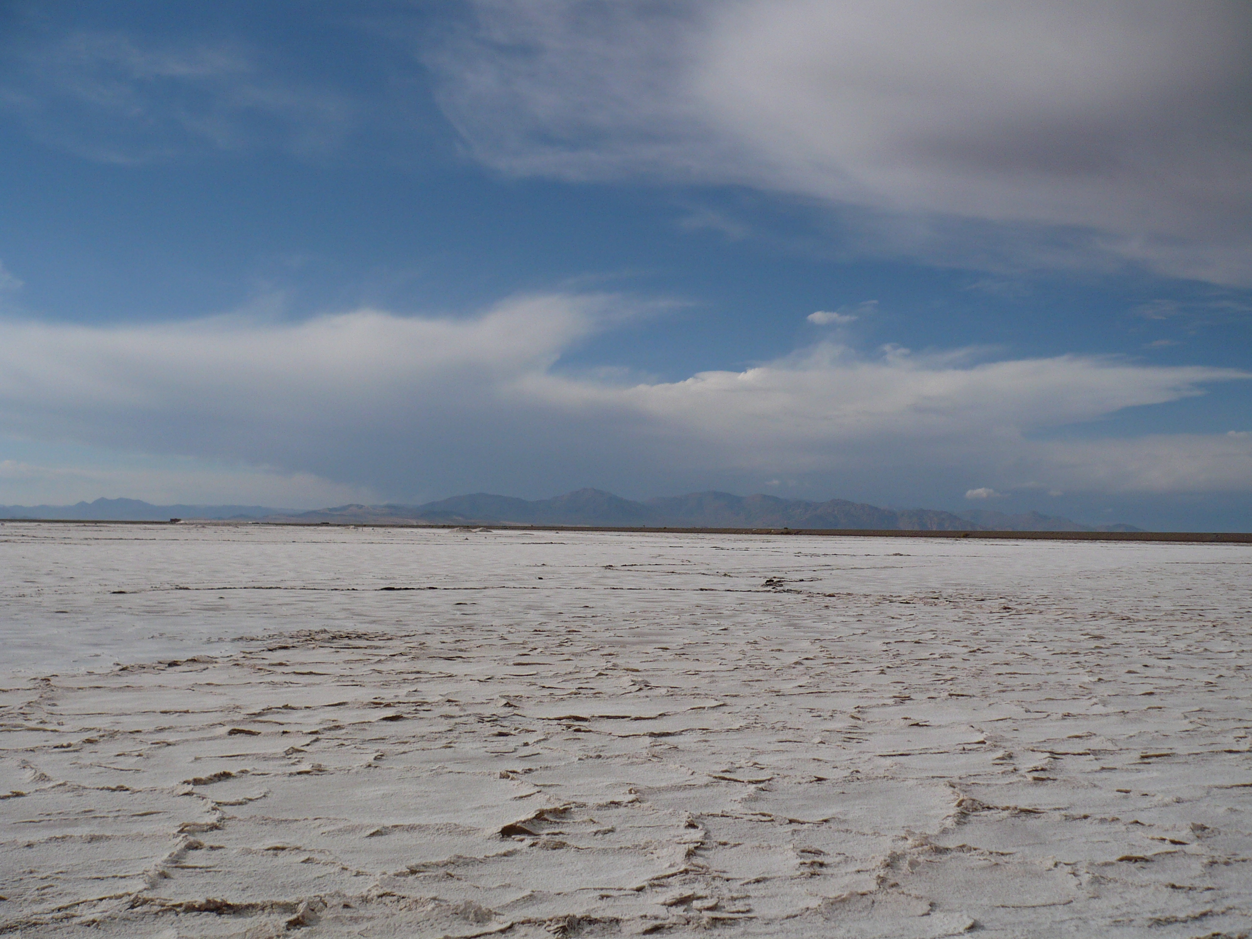
Jujuy Puna · RN 52 · Cochinoca Department
Salinas Grandes is an extraordinary salt plain on National Route 52. This independent guide brings together context and practical orientation for a prepared, respectful visit.
Puna altitude, radiation and weather shape the experience. Carry water, warm layers, UV-filtering sunglasses and sunscreen, and check the road status before leaving.
Weather now
Current conditions and the several-day forecast to help plan a Puna trip.
Mainly clear
7°C
Feels like: 2 °C · Rain chance: 0%
Model: 09:15
Next days
These landscapes share salt, bright horizons and high visual impact, but they are distinct places with different geography, access rules and visitor context. This comparison keeps the focus on the Great Salt Flat Argentina visitors find on this site.
| Compare | Argentina's Great Salt Flat Salinas Grandes, Jujuy | Bonneville Salt Flats Utah, USA | Salar de Uyuni Bolivia |
|---|---|---|---|
| Location & region | Jujuy Puna, northern Argentina, in the southern Andes. | Great Salt Lake Basin, Tooele County, Utah. | Southwestern Bolivia, on the Altiplano. |
| Elevation | c. 3,450 m / 11,319 ft | c. 1,300 m / 4,265 ft | 3,656 m / 11,995 ft |
| Key highlights | Signature deep-blue natural water eyes (Ojos de Agua), hexagonal salt-crystal textures and crystallisation pools within a working high-Puna landscape. | Hard white salt crust, BLM-managed recreation and a land-speed-racing heritage. | An expansive, windswept Altiplano salt flat with a distinct Bolivian character. |
| Accessibility | RN 52 from Purmamarca or Salta via Cuesta de Lipán; a seamless day trip with same-day confirmation of weather, road status and guided entry. | I-80, Exit 4 near Wendover; public access is subject to seasonal and event closures. | A separate southwest-Bolivia destination; local routes and tour conditions should be checked independently. |
Focus of this guide
From Purmamarca, RN 52 climbs through Cuesta de Lipán before reaching the salt flat. The road journey is part of the experience and requires high-altitude preparation.
A useful distinction
Bonneville is a BLM-managed recreation area in the western United States. Salinas Grandes is an Andean Puna landscape where local guided access, salt production and mountain conditions shape a different kind of visit.
Trip planning FAQ
Use these distinctions to plan responsibly. Conditions, road access and local rules can change without notice.
Salinas Grandes is 66 km from Purmamarca on RN 52, over Cuesta de Lipán. There is no direct public bus according to Jujuy Turismo, so organise a vehicle, transfer or excursion in advance. Treat the journey as a high-altitude road trip and check conditions again on the day.
At Salinas Grandes, weather can prevent entry to the interior. At Bonneville, the BLM limits vehicle use when the salt is wet or standing water is present and may restrict access during permitted events. Conditions at Salar de Uyuni should be checked locally and separately; no table or forecast replaces a same-day access notice.
No—rules are specific to each place. In Salinas Grandes, visitors follow local guides on established tracks. Bonneville allows driving only when it is open and conditions permit. For Salar de Uyuni, follow the instructions of local authorities and the operator you choose.
Salinas Grandes sits around 3,450 m and Salar de Uyuni at about 3,656 m, while Bonneville is much lower at roughly 1,300 m. High-Puna and Altiplano itineraries call for a conservative pace, warm layers, water and sun protection. Build extra time into the route rather than treating altitude as a quick roadside stop.
No. The weather panel on this site uses fixed coordinates for Salinas Grandes, Jujuy only. For Utah and Bolivia, use the relevant local authorities, visitor information and current operator guidance before travelling.
National tourism information describes Salinas Grandes as a former lake environment whose evaporation formed the salt flat. In pre-Hispanic times, salt was transported by llamas and donkeys; today, its pools and interior tracks still show that this is also a working landscape.
The route
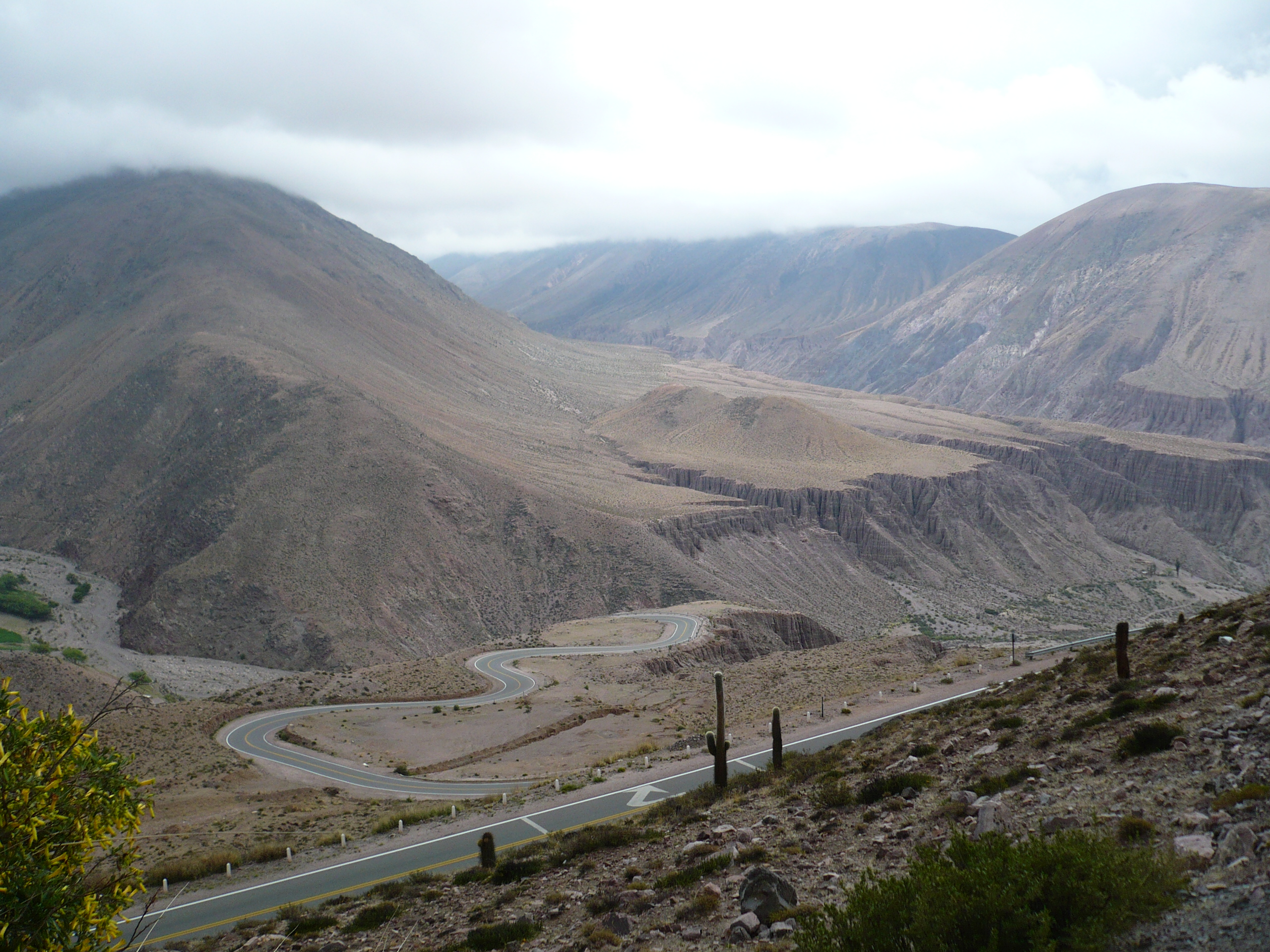
From Purmamarca, RN 52 climbs through Cuesta de Lipán, whose highest point reaches 4,170 metres according to provincial information. The road is paved, yet mountain conditions and current road status must be checked before travel.
Entry to the interior is done with local guides and on established tracks. The route commonly includes crystallisation pools and the salt flat’s water eyes. Do not enter by unauthorised tracks: surface conditions, extraction work and navigation all require care.
The Jujuy Turismo page lists this amount for guided accompaniment. Fees and conditions can change; confirm directly before travelling.
Guide service starts from 8:30 and may finish between 17:00 and 18:00 depending on season. Morning and late afternoon are usually gentler than noon; allow roughly 1.5 hours for the guided route, plus ample time for high-altitude travel.
The roadside parador is described as a visitor point with parking, souvenirs and access to the route. Given the altitude and distances, arrange essential needs before leaving your base town.
A parking area is reported beside the parador. Follow the direction of people working on site, and do not drive outside marked tracks.
Ask the parador what is available that day. Bring sufficient drinking water; do not depend on restocking within the salt flat.
Plan food and drinks from Purmamarca or another base town. Simple options may be present in the area, but availability is not guaranteed.
Do not assume fuel, EV charging or continuous signal near the salt flat. Start with enough range and a return plan.
In high season or rainy conditions, use this sequence as a final trip check. Amounts and access details in this guide are references, not an operational notice.
Check Jujuy Turismo’s Salinas Grandes page for guide hours, weather-related restrictions and current general visitor guidance.
Open Jujuy TurismoBefore climbing RN 52, compare current notices from Jujuy Tourism and road authorities. If conditions change, follow their guidance over any earlier plan.
Open Jujuy TourismOn arrival, ask local guides directly about the per-vehicle fee, payment methods, final entry time and whether the interior route is open.
View admission reference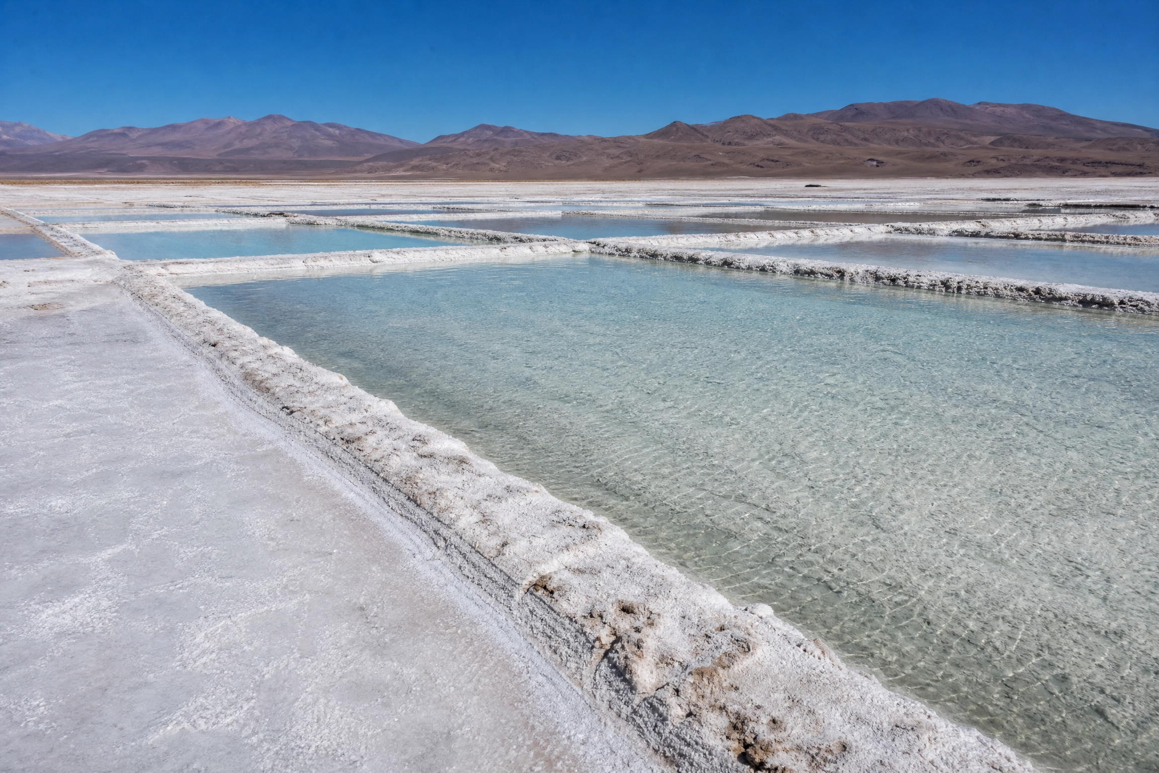
The nearest airport is Governor Horacio Guzmán International (JUJ), near San Salvador de Jujuy. There is no direct public transport from there: rent a car, book a transfer or join an excursion in advance. The drive to the salt flat takes about 3 hours via Route 9 and RN 52, through the Quebrada de Humahuaca and over Cuesta de Lipán.
The usual route leaves Purmamarca on RN 52 and climbs Cuesta de Lipán to nearly 4,170 m. It is about 66 km from Purmamarca to the parador; allow roughly 3 hours from San Salvador de Jujuy and 4–5 hours from Salta via RN 9 and RN 52. The road is paved, but check conditions and fuel up before the climb.
There is no direct public bus to the salt flat according to Jujuy Turismo. You can reach Purmamarca, Tilcara or Humahuaca by bus (lines from San Salvador de Jujuy) and from those towns hire an excursion or transfer to the salar. Compare schedules, what each trip includes and the return time.
In Purmamarca and other Quebrada towns you can arrange a remís or taxi. Agree in advance on waiting time, the return trip and the plan if weather blocks access. Ask for a driver familiar with RN 52 and altitude.
From San Salvador de Jujuy, Tilcara, Humahuaca or Purmamarca, day trips usually include a guide, the accompanied visit on the salt flat and viewpoint stops. Confirm what is included (guide, entry, food) and the latest return time before booking.
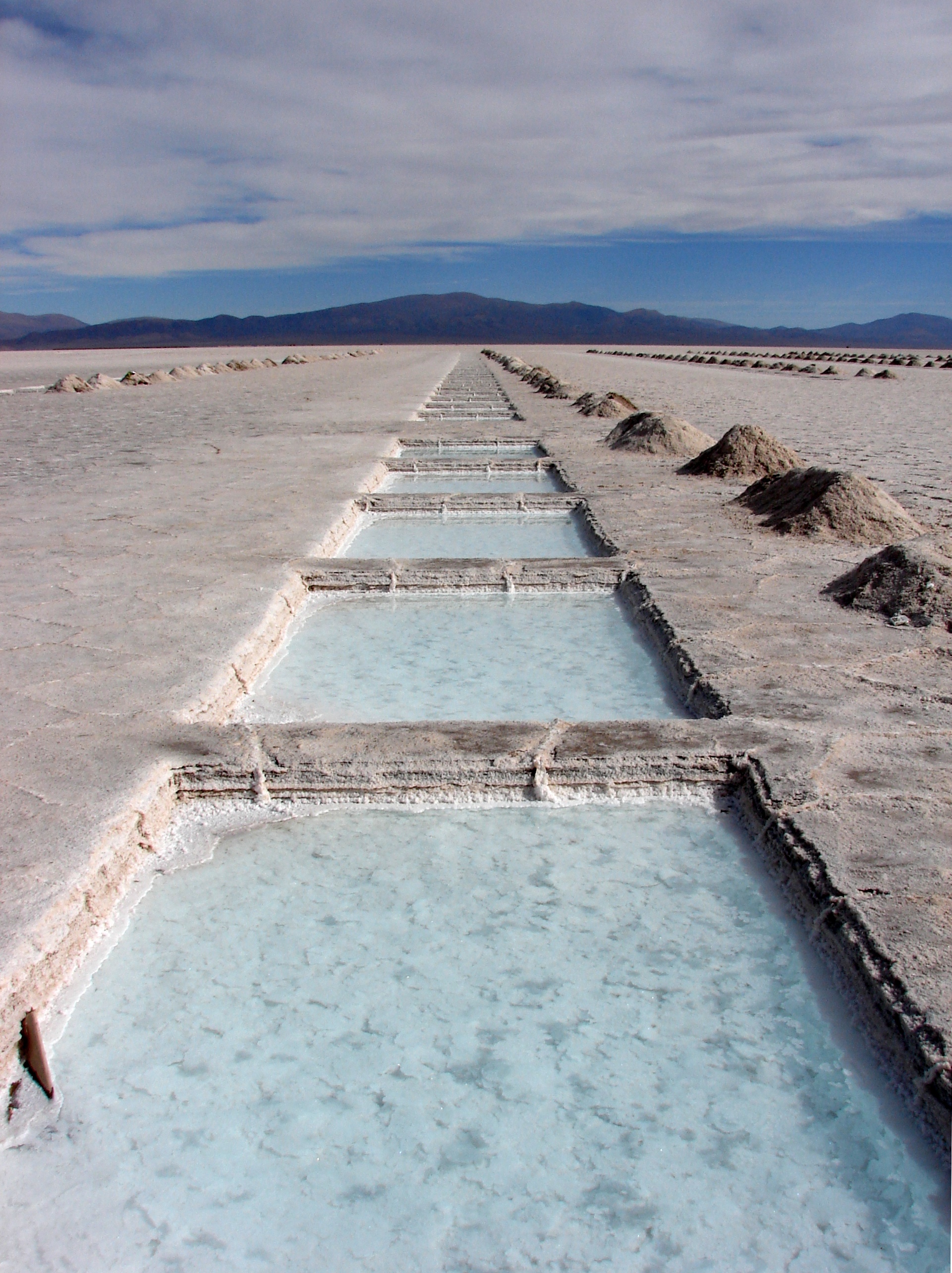
Documentary pool photograph: Guerretto, CC BY 2.0, via Wikimedia Commons.
View attribution and licencePurmamarca is the nearest base for lodging, restaurants, small food shops, cash access and transport providers. For a day visit, purchase water and food before the ascent. If you continue into the Puna, choose a rest stop based on the route, weather and your own acclimatisation.
The departure point for RN 52 and a service reference for preparing the ascent.
The mountain section of RN 52, where scenery and altitude change sharply.
A large Andean cultural landscape, with towns that can serve as itinerary bases.
The international continuation of RN 52; use requires separate planning for border documentation and weather.
Location
Use the map as a starting point, then confirm current driving conditions through official sources before departure.
The roadside parador on Ruta Nacional 52 is the support point for visitors to the salt flat. Given the altitude and distances, arrange essentials before leaving your base town. The following describes categories of services, never specific businesses.
The parador has toilet facilities; it is worth confirming the day’s availability with the people working there. Bring your own water: there is no rest or reliable refill inside the salt flat, and dehydration at altitude sets in quickly.
A parking area sits beside the parador, marked for vehicles doing the guided route. Do not drive outside the authorised tracks.
In Purmamarca and other base towns you will find restaurants, cafés and small markets. Simple options may exist near the salt flat, but availability is not guaranteed; stock up before the climb.
Accommodation (hotels, inns, cabins and organised camps) is concentrated in Purmamarca, Tilcara, Humahuaca and San Salvador de Jujuy. There is no lodging inside the salt flat.
The towns of the Quebrada de Humahuaca have grocery stores, craft shops and basic services. Carry cash: electronic payments are not always reliable in rural areas.
Refuel in San Salvador de Jujuy, Tilcara or Humahuaca before ascending. There are no fuel stations or chargers for electric vehicles at the salt flat; leave with a full tank and a margin of range.
The Puna has high-altitude weather: intense days, cold nights and strong radiation. The table summarises typical regional patterns (indicative averages, not a forecast).
| Season | Weather and sky | Access and surface | Recommendation |
|---|---|---|---|
| Summer (Dec–Mar) | Afternoon rain, storms, variable sky | Wet salt; interior may close | Check the road daily; prefer the morning |
| Autumn (Apr–Jun) | Clear days, cold nights | Stable surface, more predictable access | Comfortable window to explore at ease |
| Winter (Jul–Sep) | Dry, severe dawn cold, clear sky | Good visibility and firm surface | Dress in layers; leave after sunrise to avoid morning ice |
| Spring (Oct–Nov) | Wind and thermal contrasts | Generally stable transition | Sun protection and warm layers; watch the wind |
In the rainy season, between December and March, the salt can be covered with water and interior access changes; check RN 52 conditions on the day.
Choose by group composition and pace. All options share altitude caution and same-day route confirmation.
Favour mild hours and frequent breaks. The guided walk through the pools and water eyes is walkable, but altitude and glare demand water, a hat and sun protection from the start.
Tips
The softest light is early morning and at sunset; midday flattens contrast. The water eyes and salt crystals give shifting reflections depending on humidity.
Tips
The parador area and the salt flat view are visitable without going inside. The interior needs walking on uneven surface; assess your comfort with guides before advancing.
Tips
Two base itineraries you can combine with the Quebrada de Humahuaca.
Salinas Grandes is not a backdrop: it is a high-altitude ecosystem, a working landscape and a territory with memory.
The salt flat formed by the evaporation of ancient lakes. The salt crust and the fresh-water eyes coexist in a fragile balance shaped by rainfall and filtration.
Birds and plants adapted to the Puna endure dryness, salt and cold. Observe them without approaching or feeding; your presence already disrupts their routine.
Salt is harvested in crystallisation ponds. Respect work areas and follow only the authorised tracks with a guide.
Walk the marked tracks, leave no litter and reduce your footprint. The salt flat stays clean only if every visitor takes away what they brought.
At about 3,450 m, radiation and cold are intense. Hydrate, dress in layers and seek help if altitude sickness symptoms appear.
The visit point is on National Route 52, in Cochinoca Department, Jujuy Province. The salt flat extends between Jujuy and Salta.
No. Jujuy Turismo states that there is no direct public transport to the salt flat. A vehicle, tour, booked transfer or transport from nearby towns can be arranged.
The local recommendation is to enter with a guide and use known tracks. The interior route goes through working areas and roads that are not advised without local knowledge.
Warm layers, suitable footwear, water, sunglasses, a hat or cap and sunscreen. The altitude and reflection from the salt surface need particular attention.
Morning and late afternoon are generally more comfortable than noon. During the rainy season, between December and March, check RN 52 road status.
Place association
This guide connects the place name, location, RN 52 and Cochinoca Department to public sources. It does not replace notices issued by authorities, local guides or current road conditions.